Photogrammetry 3D Mapping
Photogrammetry and 3D mapping with drones is revolutionizing the way we capture and analyze spatial data. This cutting-edge technology offers numerous benefits across various industries, providing detailed and accurate 3D models that were previously unattainable with traditional methods. Here are some key advantages of using drones for 3D mapping photogrammetry:
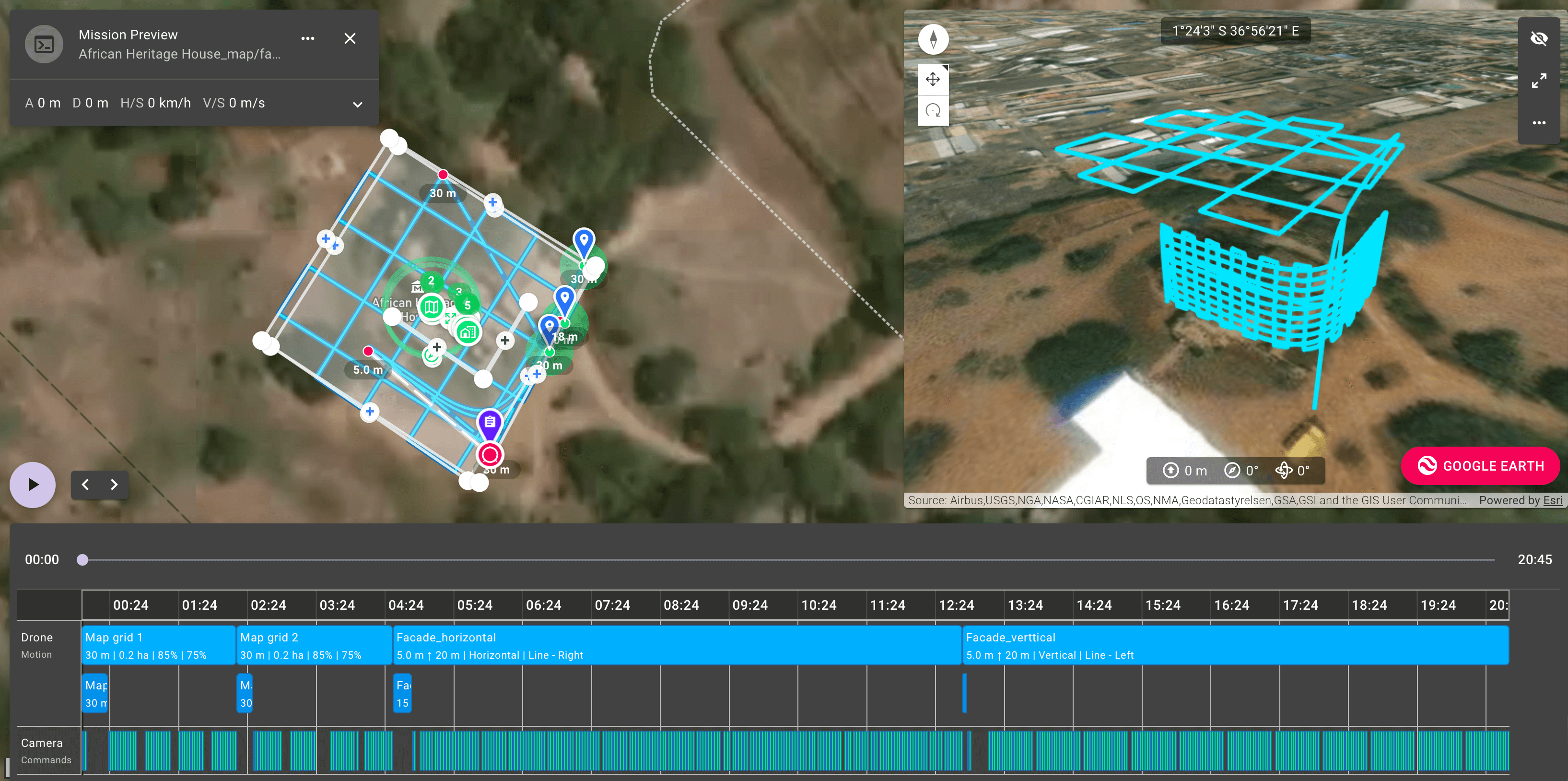
- High Precision and Accuracy: Drones equipped with advanced cameras and sensors can capture high-resolution images from multiple angles. Photogrammetry software then processes these images to create highly accurate 3D models. This precision is essential for applications such as topographic mapping, construction planning, and land surveying.
- Efficiency and Speed: Drones can cover large areas quickly, capturing vast amounts of data in a short time. This efficiency significantly reduces the time required for traditional surveying methods, which can be labor-intensive and time-consuming.
- Cost-Effective: Utilizing drones for 3D mapping is often more cost-effective than traditional methods. It reduces the need for extensive manpower, heavy equipment, and long field hours. The initial investment in drone technology can lead to substantial cost savings over time.
- Safety: Drones can access hazardous or hard-to-reach areas without putting human lives at risk. This is particularly beneficial in environments such as construction sites, mining operations, and disaster-affected areas where traditional surveying might be dangerous.
- Comprehensive Data Collection: Drones can capture data that is rich in detail, providing comprehensive views of the surveyed area. This data includes not only high-resolution images but also geospatial information that can be used for various analytical purposes.
- Versatility: Drones can be used in a wide range of applications beyond traditional surveying. They are employed in agriculture for crop monitoring, in forestry for biomass estimation, and in urban planning for infrastructure development. This versatility makes drone photogrammetry a valuable tool in many sectors.
- Real-Time Data Access: With advancements in drone technology, real-time data transmission is possible, allowing for immediate analysis and decision-making. This real-time capability is crucial in scenarios such as emergency response, where quick and informed decisions are necessary.
- Enhanced Visualization: The 3D models produced through photogrammetry offer enhanced visualization, making it easier for stakeholders to understand and interpret spatial data. These models can be used in virtual reality applications, presentations, and simulations, providing an immersive experience.
- Environmental Impact: Drones are generally more environmentally friendly compared to traditional survey methods, which may require extensive vehicle use and disturbance to the environment. Drones operate quietly and with minimal disruption to the surroundings.
- Data Integration: The data collected through drone photogrammetry can be easily integrated with other geospatial datasets, enhancing the overall analysis. This integration is beneficial for creating comprehensive Geographic Information Systems (GIS) that support various decision-making processes.
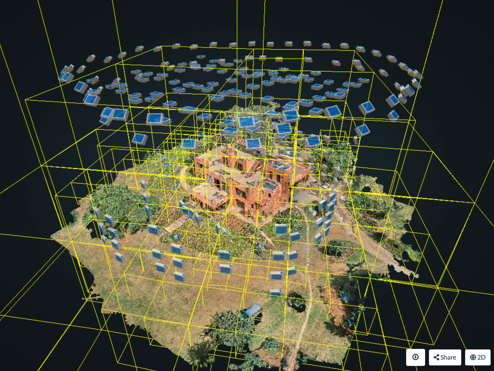
3D model is loading...
Use the mouse (finger on mobile devices) to rotate the model and scroll to zoom in and out.

